Tropical Storm Cindy Could Cause Major Flooding Across the Southeast This Week

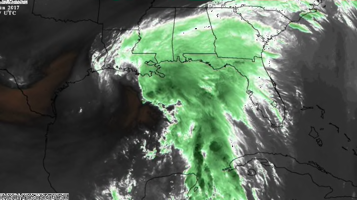
The stewing heat and humidity of a young summer finally gave way to the first tropical cyclone to threaten the United States this year. Tropical Storm Cindy is gathering steam in the Gulf of Mexico this week, and it promises to bring heavy rains to just about everyone in the southeastern United States. It won’t be a strong storm when it makes landfall, but wind isn’t as much of a concern as the copious amounts of tropical moisture being dragged northward, culminating in lots of precipitation and the potential for flooding.
As of Wednesday, June 21, 2017, tropical storm warnings are in effect for parts of the Gulf Coast from areas west of Houston, Texas, to as far east as Pensacola, Florida. Tropical Storm Cindy had winds up to 60 mph at 8:00 a.m. EDT Wednesday morning, and forecasters expect the storm to maintain winds of around 50 mph as it nears landfall. Winds of 45 mph are what you'd see in a healthy thunderstorm, but constant blustery winds over wet soil will make it easier for trees and power lines to topple over.
The traditional hurricane forecasting map—showing the forecast track of the center of the storm with a cone of uncertainty sweeping along its expected path—doesn't do much good in this situation. Sure, some areas will see gusty winds and power outages, but the real story with Tropical Storm Cindy is its rain. Cindy is a lopsided tropical storm with almost all of its heavy rain and wind shoved off to the east of the low-pressure center by wind shear higher up in the atmosphere. That's common to see in a weak, early season storm like this. Cindy's heavy rain will extend far beyond the center of the storm due to its lopsidedness and large size, so the forecast tracks we're all used to seeing don't go far enough to cover the threat posed by this storm. (If you'd like to see for yourself, forecasts are always available on the National Hurricane Center's website.)
Tropical Storm Cindy will produce rainfall totals in the double digits in some locations through the end of the week, and the moisture from its remnants will continue to track inland through the weekend. The Tuesday morning precipitation forecast from NOAA’s Weather Prediction Center called for a widespread area across the Southeast to see more than three inches of rain by the time the storm finally clears out of the picture at the end of the week. Moisture from a landfalling tropical system is usually bad enough, but this storm will run into a pesky stationary front draped across inland areas of the Southeast. This front will help wring out the moisture and make it rain harder and longer than it would have otherwise.
This much rain over a short period of time will lead to widespread flooding concerns. If you live in or are visiting affected areas, make sure you know more than one route to get to where you're going. More than half of all deaths in a tropical storm or hurricane are caused by drowning. It's impossible to tell how deep the water is on a road before you drive across it, and it takes a surprisingly small amount of moving water to lift a car and sweep it downstream.