The City That Never Seeps: The Underground History of Manhattan's Lost Minetta Brook

Not so far below the streets of Manhattan lie the remnants of a lost river. Once one of the island's major waterways, Minetta Brook—also known as Minetta Creek or Minetta Stream—used to wind through farmland and colonial estates in Lower Manhattan. And though it was paved over during the 19th century, signs of the brook can still be found in New York today.
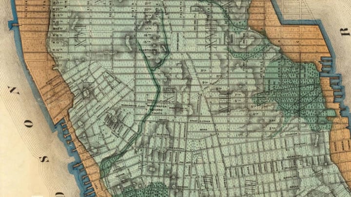
Before it was forced underground, Minetta Brook was fed by two tributaries that merged together in what is now Greenwich Village. One tributary began as a spring in the area around 21st Street and Fifth Avenue, and the other at a marsh near 16th Street and Sixth Avenue. After meeting near the future 11th Street, the brook flowed through present-day Washington Square Park and eventually dumped out into the Hudson River along the city's west side.
The history of Minetta Brook is far older than New York City itself. For centuries, the brook was known for its abundance of trout and was a popular fishing spot for Native Americans. In the 17th century, the Dutch settled in the area to farm, along with a group of "half free" African-Americans—slaves of the Dutch West India Company who were ostensibly freed and given plots of land under the condition that they pay an annual fee to the company. It became one of New York's first African-American communities, and as the neighborhood became more populous, the footpath that ran alongside Minetta Brook was referred to as the "Negroes' Causeway."
However, as Manhattan became more and more urbanized, the brook became an inconvenience to city planners and developers, and in the 1820s, it was moved underground. This was accomplished in part by leveling the hills directly east of the stream, as Sergey Kadinsky explains in his book Hidden Waters of New York City: A History and Guide to 101 Forgotten Lakes, Ponds, Creeks, and Streams in the Five Boroughs. Engineers buried the waterway in landfill sourced from the hills, then built over it.
"The engineers of those days evidently believed that the leveling of the hills, down the sides of which coursed the rivulets and the overflow from the springs which fed the Minetta, would exterminate the stream," The New York Times wrote in 1883. Of course, that water had to go somewhere. At some point in the 19th century, sewers and drains were built to divert the underground water, though the exact timeline of New York's early sewer construction is a little hazy. (Before the city came up with a systematic plan to build out its sewers in 1849, drainage infrastructure was a haphazard affair. In some cases, private landowners built their own sewers to drain their property.)
Any modern-day map of Manhattan will show that the effort to drive Minetta Brook underground was fairly successful, as all visible evidence of it seems to be gone. But if you know where to look, there are still traces of the brook in the city today.
According to some urban explorers, you can still see water from Minetta Brook in some places in Greenwich Village. One apartment building in the neighborhood, built in the 1930s, has a fountain that supposedly taps into the stream, according to the blog Scouting New York. A clear glass tube in the building's lobby runs down to the waterway, and reportedly, when the underground brook swells, you can see water bubbling up inside it. (The first time Scouting New York's Nick Carr visited the apartment building, he observed the tube looking bone dry, but on his second trip, following a rainfall, he reported seeing water "surging up in torrents.")
According to The New York Times, you might be able to catch a glimpse of the brook through a grate in a New York University Law School basement. Others claim you can still see what remains of the channel directly under the streets. During his walking tours of New York City's lost streams, for instance, urban explorer Steve Duncan peers down manholes to show water that has accumulated far below—water that appears cleaner than your average sewer sludge, as CBS New York reported after attending one of Duncan's tours. Could it be water from the brook?
Not everyone agrees on that point. Kadinsky (who, remember, literally wrote the book on the city's forgotten waters) doesn't believe the underground stream is still flowing along its natural route. Instead, he says, the water is fed into sewers that follow the modern street grid. "Nevertheless, the soil is much softer where creeks once flowed," as he said in a 2016 interview with the creators of the New York history podcast The Bowery Boys, which would explain the flooding and groundwater that many people point to as modern evidence of the brook.
Even if the brook itself is gone, there is evidence of its history woven into the urban fabric of the city. Two New York street names reference it. In Greenwich Village, a short street called Minetta Lane intersects the block-long, curved Minetta Street. (If you've seen 1973's Serpico, Minetta Street might look familiar—it's the crooked block where Al Pacino's character lives in the movie.) While curved streets are unusual in Manhattan's grid system, in this case, the bend of the street follows the natural bend of the brook.
There are subtle reminders of the brook elsewhere, too. Minetta Green Park and Minetta Triangle Park, two tiny parks in the area, both feature a small tribute to the brook: During 1998 renovations, images of trout were carved into the bluestone paths that snake through each space.
The decorative carvings serve as just more evidence that although the Minetta Brook itself might be long gone, "the neighborhood's love of history and storytelling ensured that it would never be forgotten," as Kadinsky put it to The Bowery Boys.